Imagine if you will, that you could only traverse our built environment by sidewalk. Maybe you are walking a rather inattentive dog, or have a baby stroller, or use a mobility device. How does that look?
While continuing to process our North East Avalon infrastructure map, I thought it would be nice to generate some sidewalk data once it was complete. This is a tiny screenshot of that map. (will be interactive at v1 of mapping)
Green (sidewalk both sides)
Orange (sidewalk one side)
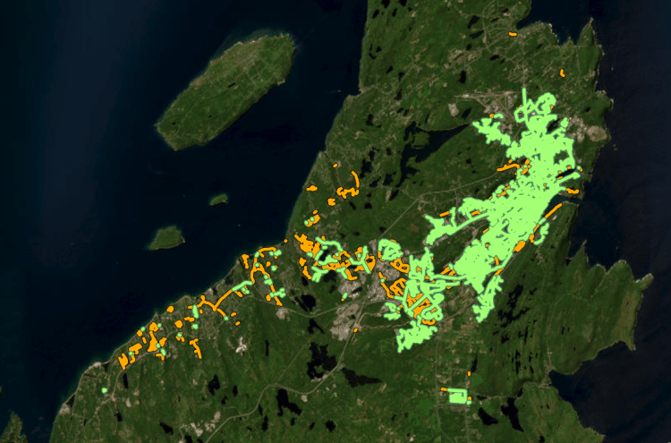
What is interesting is how much of St. John’s is a continuous network but how quickly that falls apart in the outer suburbs. Mount Pearl has a good few slower roads, fantastic off street walking trails with decent accessibility, and sidewalks on the main suburban mini-collector roads. They still lack sidewalks on the majority of their roads though, so negative points there. The core around Mount Pearl and Paradise have pretty bad sidewalk connectivity compared to St. John’s, but they are sidewalk heavens compared to CBS.
Conception Bay South has over 40 individual ‘sidewalk islands’ where sidewalks simply end. Sometimes it is a longer network with stores on it, and sometimes it is just a single cul-de-sac. Either way, it is abhorrent. Where there are no sidewalks, there are often 1:1 sloped 1m deep ditches with a narrow gravel shoulder then directly onto the road. Also, the majority of the sidewalks you do see are provincial government roads that were upgraded with sidewalks. They had little to do with the town itself. CBS is trying to improve, but with the lowest tax revenue per-capita of the 4 major municipalities on the North East Avalon, I don’t have hope that they can solve this accessibility problem. CBS is very much the definition of a car-centric suburb.
I know I just ragged on CBS, but in all honesty, Torbay, PCSP, LBMCOC, Holyrood (and the other St. John’s CMA communities) are even worse. Essentially if you live outside of St. John’s, enjoying the outdoors will only be recreation. You won’t be getting groceries, going to work/school or visiting friends/family without a vehicle. When you learn that nearly 100% of the North-East Avalon properties are vehicle accessible it really puts urban planning into perspective.
However we cannot simply look at the sidewalk connectivity itself. There are more islands than just the physical. There being a sidewalk does not mean it is pleasant or easy to traverse outside of a vehicle. We tend to avoid high speed roads and wide multi-lane roads as both are major factors as it relates to collision risk and noise impact. If people have the option to walk on a 30km/h 2 lane road, or a 70km/h 6 lane road, they’ll pick the first, all other things being equal. These could be considered another two ‘islands’ on top of the physical. A third could be sidewalk grade continuity. A sidewalk with a driveway low back segment every 6 metres is not pleasant to traverse. Lastly, snow-clearing might not be a consideration in Atlanta or Athens, but it certainly is on the Avalon. A sidewalk that is covered in snow/ice 2-4 months of the year, is as useful as no sidewalk at all.
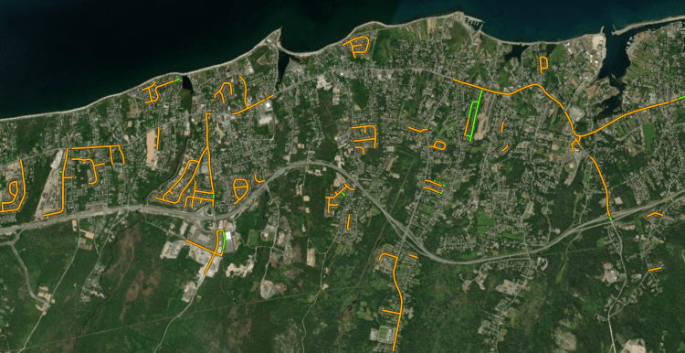
Sidewalk snow-clearing is an obvious metric to consider when people think about sidewalk accessibility. Every year there are countless stories of people walking in the street because there is nowhere else to walk. Contrary to popular lore, it is not just a St. John’s thing. It is just more apparent in St. John’s because nearly 15% of the population does not use a vehicle to get around, compared to less than 3% for all but Mount Pearl. To add insult to injury (literally), due to road geometry these folks engaging in street walking get drenched in standing water when drainage is blocked by ice/snow. There will be dozens of driver pedestrian vehicle collisions and even a fatality or two every year until we rectify these issues.
St. John’s has been putting in a solid effort into keeping a small select segment of sidewalks clear all year, which puts it on par with Mount Pearl, minus the trails.
Ever wonder why folks run/walk/stroll on the road when there is a perfectly solid sidewalk next to them? The answer is grade continuity. Sidewalks that are in the suburbs generally have a driveway cross slope every 6m. These increase the cross slope of the sidewalk from 2% to over 11%. Just as a note, that cross slope is NOT accessible compliant. Not only that, but these represent an increased slip/trip risk location.
Thankfully, the next point involving high speed roads is limited in St. John’s compared to many of our peer cities. We only have a few sections of road with 60km/h speeds. Prince Phillip Drive and Columbus Drive are the rare 70km/h zone. Walking along roads with such speeds almost guarantees pedestrian injuries/fatalities in a vehicle run-off event. None of our roads have protected spaces but due to our low walking numbers along these urban high speed roads, this is rare. However what we lack in high speed roads, we also lack in low speed roads. The majority of our residential developed streets are very wide and 50km/h. This still has high noise, vehicle speed, and risk, but traffic volumes are generally very low.
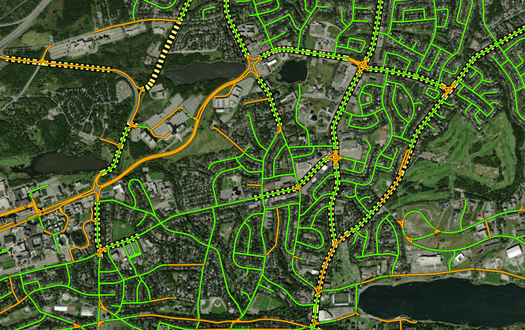
The final point for this discussion are multi-lane roads (see above), to which we have many. Every 4+ lane wide road is generally over 12m+ of uninterrupted asphalt with few safe crossing spaces. Multi-lane roads are difficult to cross for able-bodies adults, let alone children or those with mobility issues. Multi-lane roads often result in higher speeds and riskier passing events by motorists. This also results in deadlier collisions and higher noise. That higher noise is something that really cannot be overlooked. Higher noise is directly related to negative health conditions of humans and other creatures.
All of these represent different ‘sidewalk islands’. Some of these are physical, some are risk based, and others seasonal, but all are barriers to higher pedestrian usage of our built environment.
So what can be done about all of this? First off, snow-clearing on irregular grade narrow concrete sidewalks will always be complex. This goes hand in hand with grade continuity, which can be solved with a new type of road geometry: the inverted crown road. This will be a future post. Regardless, both of these issues can be solved with a new type of road that has a continuous grade asphalt surface for pedestrians users. It makes it lower impact, easier to clear, and safer to traverse. As for multi-lane roads, all we can do it hope that traffic calming and proper transportation engineering will result in less multi-lane roads. Proposals for HOV (high-occupancy vehicle) lanes and converting lanes to protected shared-use paths is another viable option. Finally, high speed roads has the easiest solution. The urban municipalities could simply mandate all speeds be dropped to 30km/h unless marked otherwise. There would be an instantaneous reduction in road noise and vehicle kinetic energy thus better reaction times and lower risks of and during collisions. It would not be popular with people when driving, but it would be popular when people are not driving (the majority of our time is not in a car… wild I know).
Sidewalks, have, in their name, the connotation of being the ‘side’. They are an amendment to a road built for cars. In the days before cars, people and animals mingled in the streets, which were for people. We can, with simple policy changes, more complicated specification changes, and complex roadworks fix a lot of issues, but it will take a brave council and an even more brave population.
Oh turd. I didn’t event get into safe pedestrian intersections, or where those sidewalks connect to. There is too much to talk about. I’ll leave that to a future post.

Thanks for this excellent article. That sidewalk snowclearing map looks pretty good until you find out that they only clear them within 4-7 days of a snowfall (which means lower priority sidewalks don’t get done at all if it snows again) while normally clearing streets for vehicles within 12 hours. Also, if you expand the map, you’ll have a better view of all the streets where they *don’t* clear the sidewalks, including sections of streets with high vehicle traffic like Empire Ave. and Prince Philip Dr. And so-called “school zones” are really just drop-off areas right in front of the school, not routes that actually enable children to walk, wheel or cycle to school safely. Lots more to say but I’m trying to stay positive so I’ll just say we can do so much better!
LikeLike