Once you start reading about transit systems all across Canada, you start to see a pattern. Big cities have transit hubs. Halifax has a half dozen, York spent tens of millions on a really shitty one, Calgary has many, Toronto has so many I can’t even count and so on. We ‘sort of’ have hubs, but they have absolutely no way-finding, are on private land, and have the issue of directional confusion.
When you see two route 10’s, what way are they going? What is 3A vs 3B? What is evening service on the route 21? Imagine you are an international student and you will be late for your exam at MUN if you don’t make a decision within the 2 minute window the buses are all at the stop. Imagine you are running late for work because your child was a little sick and now you stare at 11 buses at the Village confused as to which one to transfer to. We have many issues that could be solved with these three items.
Let’s talk about these three items.
Private land is the first issue. Metrobus wanted destinations to be relevant, so it turned to private developers. It asked them to maintain the stops and provide the covers, and in return the private entity would see more foot traffic.
The issue is change comes at a cost and someone has to foot the bill. It is hard to update a stop when it isn’t your land and property.
Hubs that are on city property allow the city to upgrade the station as demand grows and service requires. Additionally, rezoning around new purpose built transit hubs would allow the city to develop the land around the hub themselves (transit oriented development) to generate heavy revenue built people first, not car first. Having to deal with private entities is not the way to go.
Wayfinding is the use of tools like maps, signs, and technology to aid navigation, enhancing efficient transit travel.
Our current hubs don’t really have any way finding. You might find a general system map at the University Centre, or inside the Village Mall, but nothing out at the stops and no real guide on key destinations along the routes and how to transfer on.
Most covered stops only have a long list of times that each bus arrives at that destination, but that is hardly helpful if you do not know where that bus is going or what bus you even need to get on. They also doesn’t ‘visualize’ the route information.
Uncovered stops have a simple bus stop code that you can use to text Metrobus Transit to obtain ‘time to arrival’ information.
An overall system map at each transfer station platform could show all the routes that leave that platform, overlaid on the city, with key transfers and other destinations noted. Individual route maps could get more granular, show more detail on where the stops specifically are located, which ones are accessible and more. Colour, thickness, and line-type could all signify schedule, frequency, season, accessibility etc.
More to come on this soon…
Directional confusion is a big issue on a lot of systems, and ours is no different. If you are at a transfer hub, the bus should point the direction it is going, no different than a subway or train.
We have only three major hubs: The Village Mall, The Avalon Mall, and the University Centre. These stops all cater to at least 8 bus routes but all three stops are non-directional.
Non-directional means all buses face the same direction no matter where they are going. The original example of a student trying to figure out what direction route 10 is going from the Avalon Mall is the prefect example. Without a good knowledge of the system, getting on the wrong route 10 might spell an hour delay depending on the time of day. Even if you got off at the first stop in the wrong direction, you’d still have to get back to the hub station and wait for the next bus. The University Centre is even worse. We have the 1, 10, 13, 15, & 23. Yes these buses have text on the front that says the ‘destination’ they are headed in but when someone sees two route ones pull in and they have a minute to transfer, panic can lead to mistakes, and mistakes can lead to anger and a lost rider.
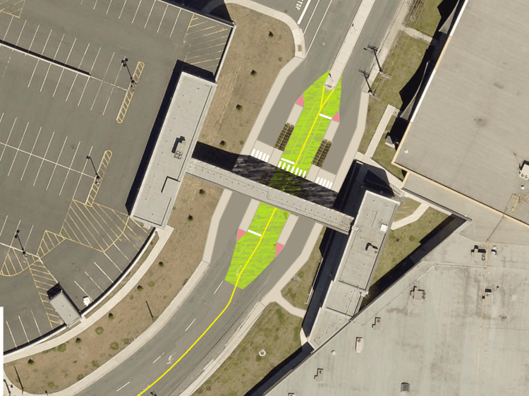
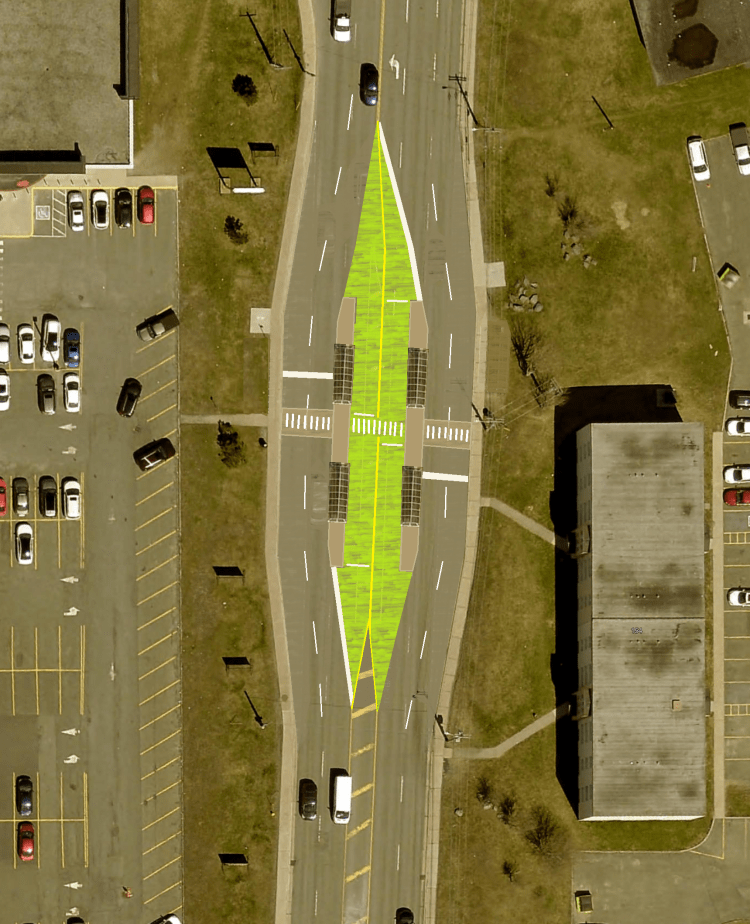
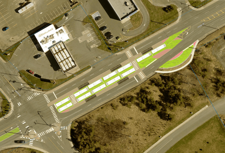
The images scattered throughout this post are about solving many issues, not just the ones noted here. By having the buses point in the direction they are headed on their route, they certainly could address directional confusion. If the stops had way-finding maps on both sides of the platform, a user could easily figure out what way the buses on their side of the platform were going and the key destinations available. These concept stops could also address land ownership by being fully on city property, and thus can be easily upgraded and expanded.
There are many other aspects of a good transit system like true express buses, frequent buses, staggered transfer windows, and more.
There is so much more to talk about when it comes to transit but we’ll end it here for now.

One thought on “Metrobus Transit hubs”