
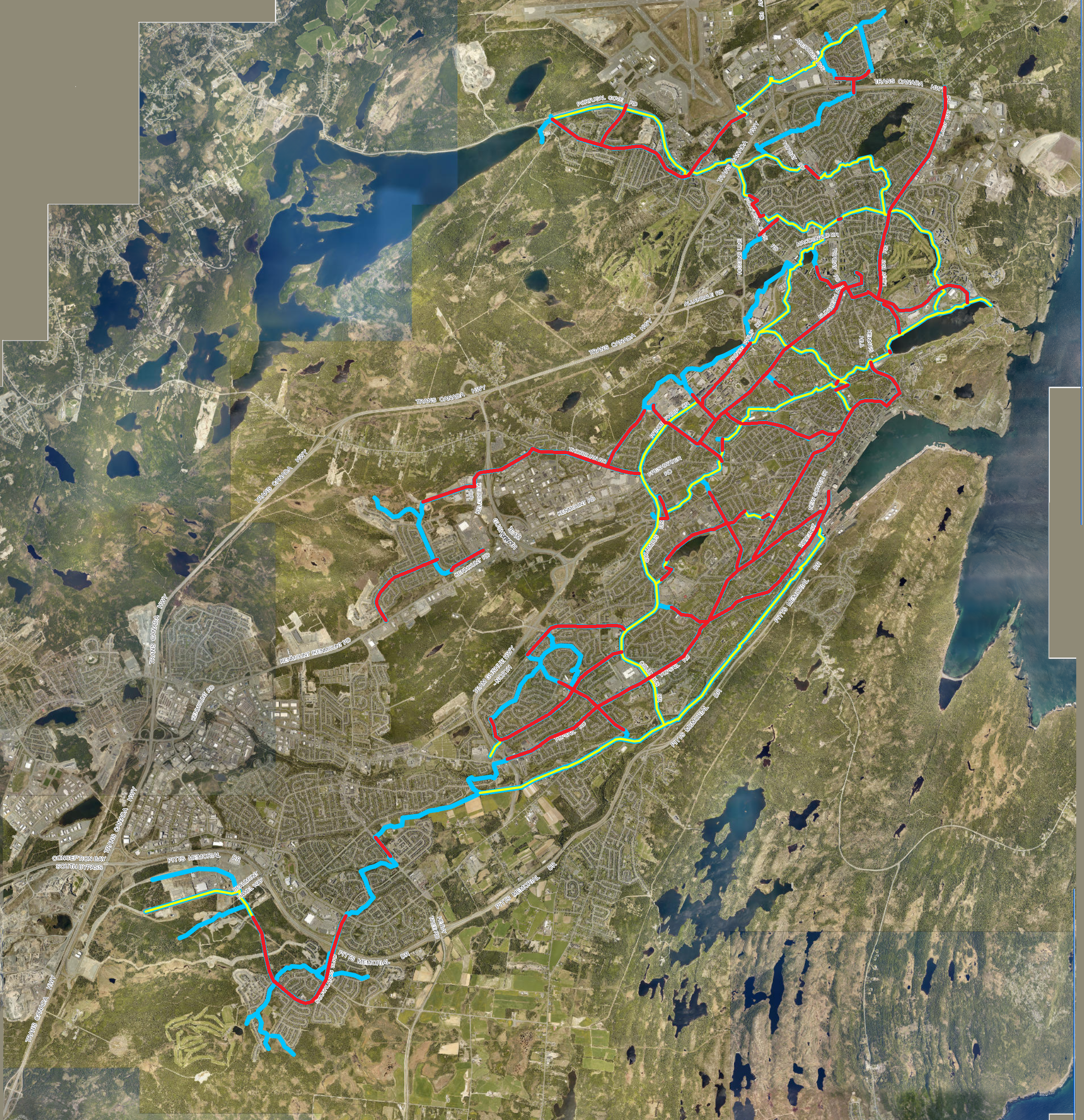
That is it. That is all that is currently existing, approved, engineered and/or under construction for shared-use and dedicated cycling paths as of the posting of this… post. We actually don’t have a single metre of protected dedicated cycle-only paths… which is fine. Dedicating paths as cycle only needlessly restricts what can be useful active transit space, at least until there are enough cyclists to warrant their own space at higher than walking speeds. There is something to be said for separating out medium velocity transport methods; that is a post for a future time.
Click here to look at the interactive map.
So there is a glaring issue with this ‘network’: there is no network. This is nine separate pieces. These pieces all require you to hop on a road (and into traffic) to continue your journey. That is a massive barrier to people cycling. There is another issue with this ‘network’: it doesn’t go anywhere. Some of these sections are laughably minimal like the couple hundred metres of Hamlyn Road. If you want to get groceries, head to school/work/a meeting or are on a road bike chances are you won’t be able to do so with the current ‘network’.
The city does have a plan to expand the shared-use path network (SUP) though. As or summer 2023, there are 3 additional projects in the pipes for connecting airport heights to the Paul Renyolds centre, a section of upgraded back trails from Portugal Cove Road to Logy Bay road, north of Macdonald drive (unless they use Kenny’s Pond), and connecting the south end of Columbus Drive to Bowring Park Trailway. Also a minor section where they are completing the gap between PPD and Columbus Drive, but this is sort of part of the Kelly’s Brook SUP project. You can find out more information on the City’s Engage website, or the City’s summary ‘what we heard’ page.
That all culminates in what you see on the left side of the below comparison slider maps and then some. The city has also added all of their proposed cycle routes for the ‘total shared-use path network’ over the next ? years. 5? 10? Who knows. This includes the infamous Canada Drive SUP, Blackmarsh upgrades, the controversial Quidi Vidi network, Thorburn road, Topsail road and more. All that said, their ambitious project has many critical issues.

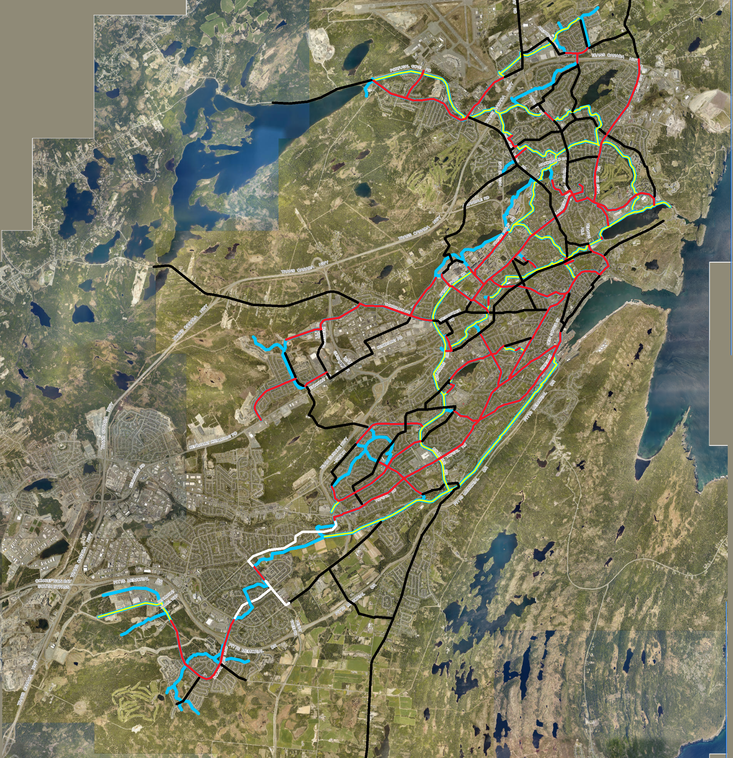
These issues will be expanded upon in later posts, but I’d like to focus on a basic tenant of good SUP’s: snow clearing. Above, I’ve taken the liberty to overlay the sections on actual roads where a wing blade machine, or full heavy equipment dedication machine can plow the shared-use path. Most of the smaller trails won’t be applicable for the larger machines, and I have doubts the sidewalk clearing machines will be able to handle the woods trail SUP’s.
All of the cities plan is based on local residents not fighting them. If the Canada Drive SUP public meetings were any indication, locals will be out to contest every single parking space that will be lost to make way for active transport, despite that our non-downtown on-street parking has less than 10% usage. However there is an easy solution to this problem: change our municipal development regulations and engineering and design specifications to include SUP’s from the get-go. People cannot complain if SUP’s are added as infrastructure spec any more than water-mains sizes, asphalt thicknesses, or concrete curb styles.
So why is snow clearing important? Well it is because modern bicycles, like modern cars, can have soft rubber wide studded tyres that make winter riding safe and effective. However a bike cannot mount a 2m high snow/ice bank. Additionally, lower velocity shared-use path users with strollers, walkers, and wheelchairs can have a much better experience with a plowed path. If we project the Cities plan out and take a look at it from a maintenance standpoint, the network would be larger, but it would still be 15 sections when it comes to snow clearing.
What the network should aspire to be is a single continuous, year round option for active transport. Someone shouldn’t have to take a circuitous U shape around a small connection. Most destinations should be more or less straight runs to major destinations. All of the network should be accessible to plow via heavy equipment.
One downside of this proposal is that it is not fully accessible. I’ve kept 100% of the routing within city rights of way and easements for avoidance of litigious land owners. That does mean some routes will be too steep to meet our accessibility standards, which is a downside. Alternative routes could also be added, but ultimately, we are quite hilly as a metro region. What this proposal is, is cheap and effective. There will be another post about HOW to implement a quick and effective 100km+ full network within 16 months or less.
There is a lot more to talk about when it comes to active transport, like cycle priority signalized intersections, continuous grade crossings, actual safe and secure destination storage for bikes (e-bikes are not cheap), and more, but that is for another time.
I’ll end with this: In addition to this network, vehicle modal filters should also be added to keep as many through cars from driving short active transit potential journeys. If we really want to try try and curb emissions, ensure that our streets are for people(😉), and promote year round healthy active transport, we need to make that the best option for most journeys. That starts with a good plan for routing.
Time to add this to the queue of data that has to be added to the database.

+1
LikeLike